Aerial Surveys, Photography, & Videography in Oklahoma
Your Precision Aerial Perspective in Oklahoma
For any aerial survey requirement across Oklahoma, including advanced magnetometer and electromagnetic surveys, LiDAR data acquisition, GIS mapping, and beyond, Oklahoma City Helicopter Charters provides a robust array of solutions. We capitalize on the inherent low-flying and precision hover capabilities of helicopters to ensure comprehensive data capture. Furthermore, we specialize in high-definition aerial filming services, offering advanced cinematography and photography technology, including the option to remove doors for specific handheld shooting requirements. For unparalleled aerial perspectives and data collection over Oklahoma, our range of capabilities is extensive.
Aerial
Surveys
LiDAR, GIS Maps, FLIR, HD Video & More
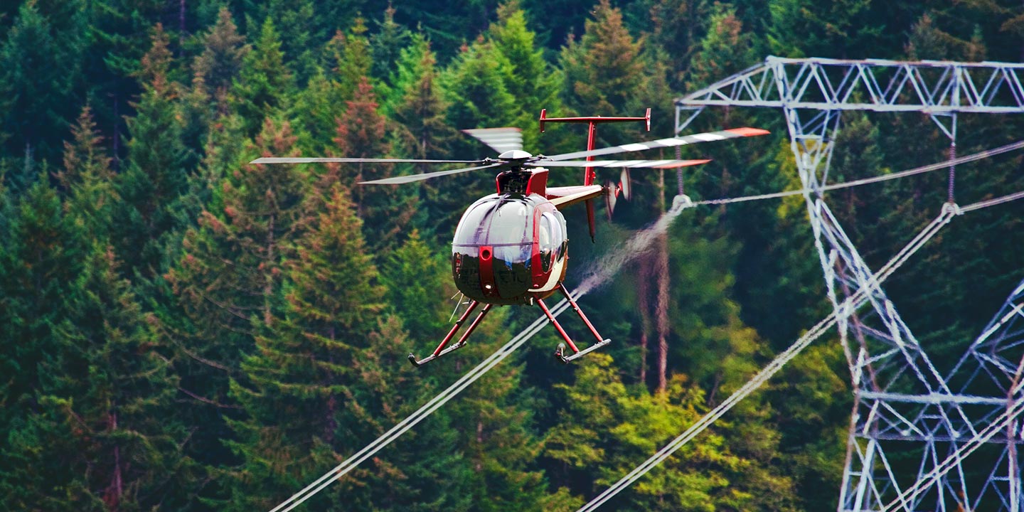
From essential pipeline surveys and critical Right-of-Way inspections to comprehensive transmission line patrols and infrastructure assessments, Oklahoma City Helicopter Charters ensures access to the appropriate aircraft and specialized equipment. We facilitate your project's successful completion with precision and reliability, supporting your operational requirements across Oklahoma.
High Tech Results
The Top Pilots in Oklahoma, Today's Technology... Maximum Results.
Call 1-866-826-4826 Now!
Oklahoma City Helicopter Charters provides the tools needed to complete your land surveys, utilizing the right equipment to provide the aerial photos that are often needed.
An efficiently executed aerial survey significantly streamlines Right-of-Way and site inspections, the acquisition of precise topographical data, or the capture of high-definition imagery for commercial development projects. Helicopter surveys represent the most effective methodology for comprehensive examination of the diverse Oklahoma terrain, enabling meticulous inspection of pipelines for integrity issues, detection of anomalies within transmission lines, or detailed photographic and video documentation of properties. Oklahoma City Helicopter Charters is adept at developing bespoke photographic and remote sensing operations, engineered to maximize both technical and financial efficiencies while delivering superior actionable results.
The inherent operational characteristics of a helicopter, enabling sustained low-altitude and slow-speed flight, position it as the optimal platform for aerial surveying. While fixed-wing aircraft are generally mandated by the FAA to maintain an altitude of at least 1,000 feet above the highest obstacle, helicopters offer the distinct advantage of operating at significantly lower altitudes. This capability is crucial for inspecting challenging or hazardous zones, providing engineers and project managers with unique, otherwise unattainable perspectives essential for comprehensive assessment.
There is no better way to conduct your visual survey, animal population counts, soil drainage analysis, ROW inspections, pipeline and transmission line inspections, and geographical surveys.

LiDAR Imaging
Light Detection and Ranging, or LiDAR, is a remote sensing method used to examine and measure Oklahoma topography as well as objects, like vegetation, upon it.

Infrared Imaging
Thermographic IR cameras are used to detect radiation in the long-infrared range of the electromagnetic spectrum and produce images of that radiation, called thermograms.

HD Video Gimbal Capture
Modern HD and 4K cameras can be mounted to helicopters, using the proper STCs, with a gimbal to stabilize photos & videos for detailed results.

Advanced Aerial Filming and Professional Videography
For expert camera work in the Oklahoma City Sky
Get a Fast, free QuoteOklahoma City Aerial Cinematography
Oklahoma City Helicopter Charters provides access to all necessary resources for professional-grade aerial cinematography across Oklahoma. Our network supports custom production requirements, offering advanced gyro-stabilized camera mounts such as Tyler Mounts, Wesscam, Cineflex, Pictorvision, and SpaceCam. These are compatible with a range of specialized cameras, including Cineflex HD, RED Epic, Arri Alexa, alongside 3D and experimental camera systems. We facilitate comprehensive support for your production goals, from intricate air-to-air sequences to precise ground-to-air shots. Our operational support ensures cinematographers and directors achieve their exact visual objectives. Specializing in helicopter services for both still and motion photography, Oklahoma City Helicopter Charters is equipped to support nearly every media-related operation throughout Oklahoma. This includes productions for film, television, documentaries, promotional videos, commercials, the provision of aerial props, critical relief work for television networks, and extensive coverage of historical and major sporting events with a diverse fleet of helicopters.
Call Us Today at 1-866-826-4826 for a Free Quote
Contact Us
Aerial Photos
Hand-held or Mounted OpTions in Oklahoma City
We will help you get the right equipment for your aerial photography project! Call 1-866-826-4826 today to get a fast, free quote.
The Most Options for Photography
The striking landscapes and unique geographical features of Oklahoma are most effectively documented from an aerial perspective. Discover the enhanced capabilities of our aerial photography charters, meticulously designed to facilitate the precise capture of your envisioned imagery. Oklahoma City Helicopter Charters offers clients access to professional photographic opportunities across Oklahoma, emphasizing value and operational efficiency. Many helicopter platforms can accommodate door removal for handheld projects; however, we strongly recommend inquiring about our gyro-stabilized mount options to achieve superior image stability and professional-grade results.
Superior Service
Every one of our customers gets a dedicated helicopter expert to assist with flight plans, tech loadouts, production logistics, project schedules, and other demands.
Over 500 Aircraft
Our network of direct air partners extends well beyond Oklahoma City, Oklahoma. This allows us to offer a wide range of solutions for even the most sophisticated projects.
The Best Equipment
From high-tech sensors like LiDAR, FLIR, and GIS to HD cameras and movie production gimbals, we're here to make your job as easy as possible.